Moldova's Topography, Nature & Climate
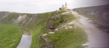
The small country of Moldova is sandwiched between →Romania in the west and the →Ukraine in the east. Due to the fact that there's a small strip of Ukrainian territory between Moldova and the Black Sea, the country is landlocked. To say that the country is mountainous would be an exaggeration. The highest peak, Dealul Balanesti, is only 430 metres high. However, almost all of the territory is quite hilly with some more or less deep river valleys, almost canyon-like, as for example in →Orheiul Vechi at the river Răut and along the longest river of the country, the Nistru (Dniestr).
Only the small stretch of land east of the Dniestr and the southern part of the country are rather flat - obviously, the seashore of the Black Sea is close. The border to Romania is marked by the long river Prut, which is also used for energy production in the north. Most of the country consists of a steppe-like landscape with some forests here and there. The summer is rather long and relatively dry; winters can become very cold. Unfortunately, the country has no significant mineral resources at all. But it offers quite fertile soils. Here and there, the surface is dominated by sediments, esp. very young chonchoidal limestone, sand, gravel, gypsum and others.
©2024 Europe-East.com
