Official Name
Tiranë. As with most other place names, this town has actually two names, and both are often used in Albania. However, outside Albania the second version is usually being used: Tirana. For this reason, only the name "Tirana" is used within this website. The name probably derives from the name Tehran, which was given to the town by the Ottoman rulers. And it's no coincidence: The name has indeed something to do with Tēhran (Teheran), the Persian or Iranian resp. capital. The Ottoman ruler who has decided the name won an important battle in Persia before he came to Albania. This is at least one theory about the origin of the name. Tirana is also the name of a small river running through the capital.
Location
| ||
| Location of Tirana |
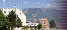
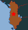
Tirana lies almost exactly in the middle of small Albania, at the point where the coastal plain meets the mountains of the hinterland. The port town of Durrës at the Adriatic Sea is about 30 km away - to the mountains in the east it's only a few kilometres. Tirana's landmark mountain is the malit të Dajtit (Mt. Dajti) and not less then 1,613 metres high. In summer, Tirana and the surroundings are arid, meaning that the precipitation is lower then the potential evaporation. In general, the climate is rather mediterranean, with lots of rain during the colder season.
Population
It's hard to get detailed numbers on the population. An official census in 2003 revealed that their are around 350,000 inhabitants, but more realistic estimates state that there might be some 830,000 inhabitants. The town is growing rapidly and uncontrolled - it wouldn't surprise me if Tirana breaks the 1 million mark before 2010.
Orientation
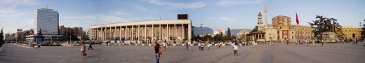 | ||
| Skenderbeg Square in the heart of the capital |
The absolute centre of town - and the political centre of Albania - is the large Sheshi Skënderbej (Skenderbeg aka Skanderbeg Square), from where all important streets start, making it appear like a large star. The centre of Tirana is characterized by broad and often green boulevards. Here and there, some old buildings are left. The Stacioni Trenit (train station) is around half a kilometre away from Skenderbeg Square at the northern end of Bulevardi Dëshmorët e Kombit. From outside, the ochre-coloured train station doesn't really look like a typical terminal, so it's easy to miss it.
In the north and the west, Tirana is simply pullulating like weeds - without any urban planning and much too quickly. In some areas, there's no difference to Third World slums. This is no surprise - the migration from Albania's poor rural areas that started 1991 washed hundreds of thousands of people into the before rather laid-back capital. The north of the town is defined by the river Tirana, which is not regulated at all. From the east, tiny river Lanë (Lana) crosses the town - but this river is mainly running in ugly canals.
History
Tirana never played a really important role before the 20th century. It was probably founded in 1614 by a local Ottoman ruler. Before that, there was only a small village, although the area around the town was inhabited already thousands of years ago. Tirana remained a small provincial town for the next centuries - always behind the larger and more important towns of Durrës or →Shkodra. Nevertheless, Tirana was declared capital of Albania in 1920, right after the country declared independence. The reason for the choice was simple: The central location. This was a compromise between the two large cultural groups in Albania - the North and the South, that is Gheg and Tosk.
This of course initiated a boom - several splendorous buildings and boulevards were built right after the independence. At that time, only some 20,000 people lived in Tirana. After the liberation of the capital and the rest of the country from the Nazi German occupation, the Communists under the leadership of Enver Hoxha came to power. Old buildings were often demolished or simply not maintained at all. There were soon to be outnumbered by socialist monumental structures and very broad roads (without cars), flanked by dull residential areas. The industrialisation was pushed forward. Simultaneously, the population grew quickly, with more then 100,000 Albanians living in the capital since the 1950ies. Around 1990, several hefty demonstrations, mainly in the capital, resulted in the collapse of the communist regime.
Since then, Albanians were free to choose where to live. Especially many poor people from the rural North of the country saw their chance and migrated to Albania's largest town. Soon, the town became too small for such a massive migration wave. Air pollution reached a frightening level, and the city is still growing so rapidly, that there is not enough time to assign names to all the new streets.
Getting there / transportation
Tirana is by all means the capital of Albania, so it's the main hub of the country. The most important (if not the only important) airport of Albania is now called Aeroportin Nënë Tereza (Mother Teresa Airport) and lies around 30 km northwest of the centre of town. Regular shuttle buses run between the airport and the centre.
Several trains start and terminate in the capital, none of them international. Destinations include Pogradec, Durrës, →Shkodër etc. There is no central bus terminal yet - depending on the destination, buses and microbuses start from various - often hard to find - bus stops all over the town. Inside the city, it's best to get around on buses - bus routes are well explained and easy to get along with. However, the centre and with it Tirana's biggest sights are concentrated in a rather small area, so everything is within walking distance. For more information on how to get to and from Albania in general, see → Albania: Travel Information.
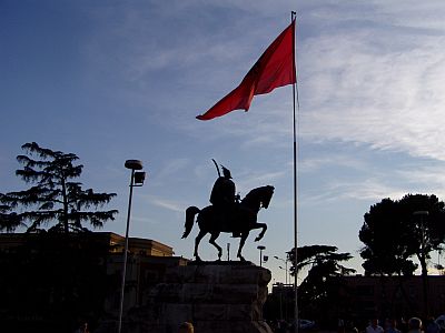
As already mentioned above, almost everything in Tirana concentrates around the large Sheshi Skënderbej (Skenderbeg / Skanderbeg Square). The square is so large that it's not possible to see every corner from a single place. The middle of the square is not open to traffic and characterized by a prominent monument depicting the Albanian national hero on his horse - in front of it the huge red Albanian flag with the black twin-headed eagle in the middle. The southern part of the square is dominated by a lovely combination of several older buildings forming a semi-circle. Most of the buildings are used by the government and were built around the 1930ies.
| ||
| Skanderbeg monument |
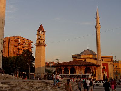
In fact, there is only one corner of Skanderbeg Square which is faced by old buildings - but those buildings are almost completely smothered by the massive concrete architecture around. In detail, those buildings are a mosque and, right behind the mosque, a 35 m high clock tower which can be climbed. Construction of the Xhamia e Tiranës (Tirana Mosque) started in 1794 and wasn't finished before 1821. During the reign of Enver Hoxha, practising religion was strictly prohibited, but now it's actively used again. Apart from that, there do not seem to be many mosques in town. One of the reasons for this might be the fact, that Tirana was a tiny town until the 1920ies.
| ||
| Mosque in the centre of town |
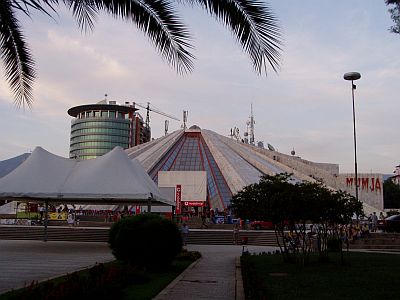
From Skanderbeg Square, the broad Blvd. Dëshmorët e Kombit (Boulevard of the Martyrs of the Nation runs southwards straight to the main university. Several marvellous buildings and many trees line up along the boulevard. Halfway, it crosses the concrete, dead straight river bed of the small river Lana. Lefthand, when coming from the square, stands an oddly shaped structure, which looks like a circus arena made of ... concrete. As everyone would expect from a decent dictator, Enver Hoxha had his own Mausoleum built right in the centre of town. In 1990 however, he had to move: Today, the structure is used as an International Cultural Centre.
| ||
| Former Enver-Hoxha-Mausoleum |
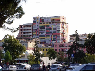
One thing is noticable within hours - this place is in transition. Wherever you walk - everywhere construction sites and countless new buildings or at least restaurated buildings. Right after Berlin, Tirana is probably the fastest changing capital in Europe. In many places, large apartment blocks of various types, painted with bright colours in abstract patterns (see picture below), catch the visitors eye. This unique facelifting was suggested by the mayor Edi Rama, an international artist and ex-basketball player, who is serving the city as mayor since 2000. His rule is not without opposition, but his campaigns to make Tirana a brighter, more beautiful place were definitely successful - at least in the centre. He was even elected "World Mayor" in 2004 by the internet community.
| ||
| The renaissance of the capital is on its way |
The concept of the Rilindja e qytetit (Urban Renaissance) works well. In many places, the town looks fresher and cleaner. But there's a huge amount of work left - and it's often only the facade (don't ask for the interior of those apartment blocks...). But Tirana turning into a more attractive, booming capital.
| ||
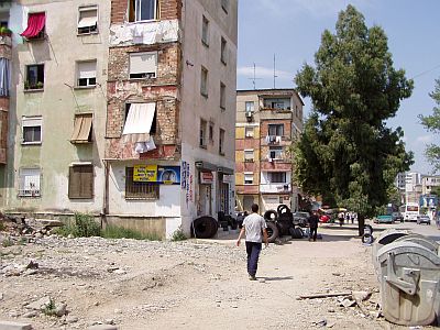
| Typical residential area not far from the train station |
Unfortunately, I only had a day in Tirana - not enough to get a good idea of the town. My impression was that Tirana is worth a visit, but there are many other, partially more interesting places in Albania. However, there are many more places to see in Tirana - many parks, museums etc, so there is more to discover than described above.
My visit to the capital was too short to get an idea of the surroundings. Some Tiranians I talked to recommended climbing the landmark mountain Dajti - and I'm sure the view from the top is breathtaking. Other sights include nearby Kruja - a traditional mountain village. Elbasan and Durrës, the port town, are close to the capital as well.
Today there is even a Tirana Backpacker Hostel, which opened in June 2005. According to staff members, I was the 20th or so guest. The hostel has two dormitories with 5 beds each and a 3-bed room. And a very lovely veranda. Staff members are very young and very nice people. At least back in 2005, it was only possible to check in between 4 and 8 pm. However, staff wasn't angry when someone "checked in" at night and paid the next day - provided another guest opened the door at night. The price for one night is/was 1,500 Leke (about € 12).
The location is quite convenient - just walk along above mentioned Boulevard of the Martyrs of the Nation southwards from the central Skenderbeg Square. Turn left right before the posh Europa Park-Hotel and just walk straight ahead to the end of the street - there's a yellow villa right at the end. In summer 2005, there was no sign at all telling that the villa would be the hostel, but this probably has changed already. Nearby, there's everything the traveller needs - super markets, café, internet cafe etc. Address: Rruga Elbasanit 85. Tel: ++355-(0)682167357.
Walk from the hostel straight ahead (with the hostel in the back) along Ismail Qemali rd, cross the broad Boulevard of the Martyrs - and there you are, right in the middle of the #1 entertainment district Blloku. A fascinating place with plenty of entertainment every night - countless posh bars and restaurants, mini skirt wearing young Albanians (some of them clearly tending to be exhibitionists) etc. A sharp contrast to the rest of the country - personally, I was surprised to find some sort of Khao San Rd. in Tirana.
- www.tirana.gov.al: Official, well done website of the administration - in Albanian and English and quite helpful.
Do you have or do you know a good website about Tirana? Don't hesitate, let me know! After checking it, I would love to add it to the link list. You can submit a link by using the →contact form. Note that commercial websites will be treated differently.
©2024 Europe-East.com
